- Region
- Águilas
- Alhama de Murcia
- Jumilla
- Lorca
- Los Alcázares
- Mazarrón
- San Javier
-
ALL AREAS & TOWNS
- AREAS
- SOUTH WEST
- MAR MENOR
- MURCIA CITY & CENTRAL
- NORTH & NORTH WEST
- TOWNS
- Abanilla
- Abarán
- Aguilas
- Alamillo
- Alcantarilla
- Aledo
- Alhama de Murcia
- Archena
- Balsicas
- Blanca
- Bolnuevo
- Bullas
- Cañadas del Romero
- Cabo de Palos
- Calasparra
- Camping Bolnuevo
- Campo De Ricote
- Camposol
- Canada De La Lena
- Caravaca de la Cruz
- Cartagena
- Cehegin
- Ceuti
- Cieza
- Condado de Alhama
- Corvera
- Costa Cálida
- Cuevas De Almanzora
- Cuevas de Reyllo
- El Carmoli
- El Mojon
- El Molino (Puerto Lumbreras)
- El Pareton / Cantareros
- El Raso
- El Valle Golf Resort
- Fortuna
- Fuente Alamo
- Hacienda del Alamo Golf Resort
- Hacienda Riquelme Golf Resort
- Isla Plana
- Islas Menores & Mar de Cristal
- Jumilla
- La Azohia
- La Charca
- La Manga Club
- La Manga del Mar Menor
- La Pinilla
- La Puebla
- La Torre
- La Torre Golf Resort
- La Unión
- Las Palas
- Las Ramblas
- Las Ramblas Golf
- Las Torres de Cotillas
- Leiva
- Librilla
- Lo Pagan
- Lo Santiago
- Lorca
- Lorquí
- Los Alcázares
- Los Balcones
- Los Belones
- Los Canovas
- Los Nietos
- Los Perez (Tallante)
- Los Urrutias
- Los Ventorrillos
- Mar De Cristal
- Mar Menor
- Mar Menor Golf Resort
- Mazarrón
- Mazarrón Country Club
- Molina de Segura
- Moratalla
- Mula
- Murcia City
- Murcia Property
- Pareton
- Peraleja Golf Resort
- Perin
- Pilar de la Horadada
- Pinar de Campoverde
- Pinoso
- Playa Honda
- Playa Honda / Playa Paraíso
- Pliego
- Portmán
- Pozo Estrecho
- Puerto de Mazarrón
- Puerto Lumbreras
- Puntas De Calnegre
- Region of Murcia
- Ricote
- Roda Golf Resort
- Roldan
- Roldan and Lo Ferro
- San Javier
- San Pedro del Pinatar
- Santiago de la Ribera
- Sierra Espuña
- Sucina
- Tallante
- Terrazas de la Torre Golf Resort
- Torre Pacheco
- Totana
- What's On Weekly Bulletin
- Yecla


- EDITIONS:
 Spanish News Today
 Alicante Today
 Andalucia Today
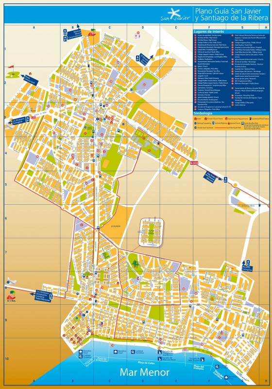
Street map for San Javier and Santiago de la Ribera
Street map of San Javier and Santiago de la Ribera
The main bulk of the municipality of San Javier is on the "mainland" side of the Mar Menor, and includes the town of San Javier itself and the beaches of Santiago de la Ribera, which is the administrative district occupying the coastal section of the Mar Menor within the municipality.
The other part of the municipality lies on the opposite side of the Mar Menor on the strip of land known as La Manga del Mar Menor. This long thin spit of land encloses the Mar Menor, dividing it from the Mediterranean and creating Europe's largest saltwater lagoon.
La Manga is shared by two different municipalities; Cartagena administering the southernmost end and San Javier the northern part. The two areas of San Javier are connected by a ferry service from Santiago de la Ribera to La Manga del Mar Menor.

Click here to download a PDF version of the street map.
Click here for more information about the San Javier municipality: SAN JAVIER TODAY
