Playa Banco del Tabal - La Manga del Mar Menor Beaches
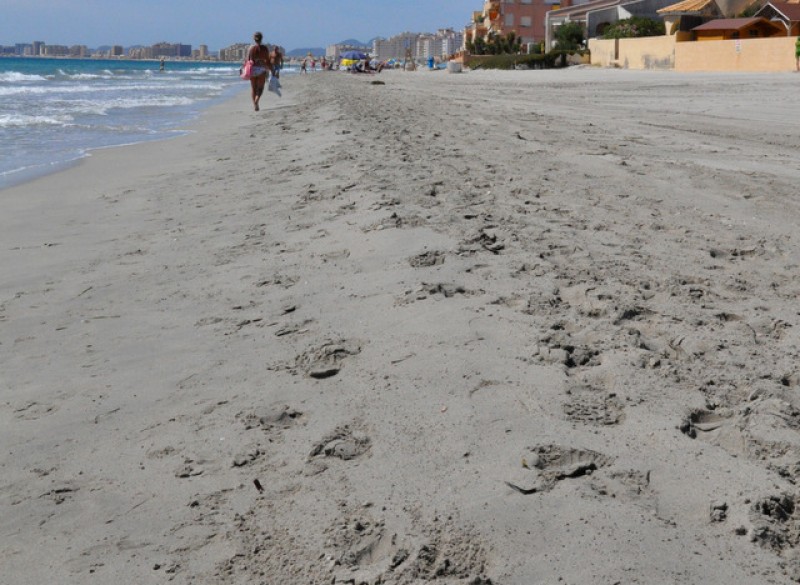
Playa Banco del Tabal is a 1400 metre long Mediterranean coastal beach with soft golden sand
Playa Banco del Tabal is one of a series of glorious wide, open Mediterranean beaches which run down the Mediterranean coastal side of La Manga del Mar Menor, is 1400 meters long and 15 metres wide.
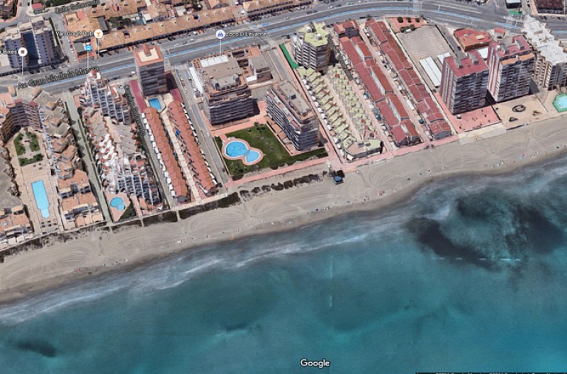
Banco del Tabal beach is close to the beginning of this long strip of land enclosing the Mar Menor and lies between kilometres 3.5 and 4.9, servicing the urbanisations between Star Alfa and Gaviotas.
This area of La Manga del Mar Menor is densely built with construction on both sides, and so has high occupancy during the peak summer months as a result, although is a popular residential area throughout the year.
The beach is fine and sandy, becoming more “natural” as it nears the Gola de Marchamalo, a protection zone where the Encañizada fishing technique is still practised, a technique which involves creating fish traps using canes driven into the mud to form a “labyrinth” from which the fish find it difficult to escape. This area marks a natural channel through which water from the Mediterranean feeds into the Mar Menor.
Services and facilities include toilets, telephones, beach grooming service, bins, wooden walkways, footwashes and beach chiringuitos, plus there are plenty of bars, shops and restaurants in the area.
The beach is well-adapted for disabled users, offering reserved parking, access ramps, wooden walkways, adapted toilets, bathing chairs and amphibious crutches. There is also an assisted bathing service, offered by the Protección Civil during the months of July August, between 11:00 and 19:00.
Access: There is a bus service which runs right along the length of La Manga throughout the day with several stops giving access to the beach and parking for cars in the urban areas which back onto it.
Click for more information about La Manga del Mar Menor.
Basic information about San Javier municipality beaches
San Javier has 2 totally distinct sections of beaches, one part being in Santiago de la Ribera, close to the main centre of San Javier town, all of which are Mar Menor beaches, and the other across the opposite side of the Mar Menor on the La Manga strip, at La Manga, which are a mixture of Mar Menor and Mediterranean beaches.
Mar Menor beaches are enclosed within the protective circle of what is, essentially, Europe's largest saltwater lake, although it's often difficult to think of this as a lake as it is fed by the Mediterranean, and is on the Mediterranean coastline.
The Mar Menor is totally unique, its geographical peculiarities creating some of the best conditions in Spain for those learning watersports, particularly windsurfing and sailing.
Murcia is the warmest mainland region in Spain, and has an average temperature of 18 degrees, which makes it perfect for year-round watersports activity and bathers can enjoy the waters of the Mar Menor for most of the year. The water in the Mar Menor is not tidal and has no currents or waves, so is perfect for family bathing or watersport beginners.
It has shallow fringes, which slope gently, and is only 7 metres deep in the centre, so the water temperature is warmer than that of the Mediterranean, particularly around the edges where it is possible to wade out 50 metres from the shore and still only be waist deep.
All of the beaches listed as Mar Menor beaches are inside the circle of the Mar Menor, which covers a surface area of nearly 170 square kilometres, with 70 kilometres of internal coastline, separated from the Mediterranean by a 22km long strip of land (the La Manga Strip as it's often referred to by foreign visitors, or La Manga del Mar Menor), which is connected to the Mediterranean via a canal channel, so sailing boats can sail between the Mar Menor and Mediterranean and the water retain its salinity.
The internal area of the Mar Menor is divided between several municipalities, or local councils. The La Manga strip is divided into two sections for administrative purposes, although there is no geographical difference, the far end belonging to San Javier and the lower section linking to Cabo de Palos belongs to Cartagena.
The La Manga Strip offers beaches on both the Mar Menor side and the Mediterranean coast, both presenting totally different bathing conditions and types of beaches.
It is important when selecting a beach to understand that the Mar Menor beaches offer shallow and calm bathing conditions, whereas the Mediterranean beaches are wider, longer, windier, and are susceptible to wave conditions and currents.
Beach location is generally defined by "km", as the various points along La Manga del Mar Menor are listed as being "at km....". Basically KM 0 is the tourist information point at Cabo de Palos and km 18 is the far end of La Manga by the Esculls de la Llana y Encañizadas which is where dry land runs out! The remainder of "the strip" is marsh, and inaccessible, before it finally meets the salinas of the San Pedro del Pinatar municipality.
Click for more information about the San Javier municipality
Click for an introduction to beaches in the San Javier municipality
article_detail
|


 Welcome To